Polar Vortex: a counterintuitive threat of climate change?
Alex Pui and Sileem Horie shed light on the climatology of the polar vortex and the unique circumstances and vulnerability of locations most impacted, before offering suggestions on how societies can better economically prepare for similar storms in the future.
On 13 February 2021, a powerful winter storm descended upon Texas and other parts of southern United States, bringing widespread record low temperatures of more than 20°C below average conditions over a large area that usually experiences mild winters. Texas was the state that was hit the hardest. At the height of the storm, up to 5 million homes reported power outages, and with extreme cold temperatures persisting for over a week, it meant that millions of Texans were left without heat or power at a vulnerable moment during the COVID-19 pandemic. Sadly, the death toll of the storm now stands at 57, and the projected economic cost of winter storm Uri (USD200 billion)[1] is on track to rival and perhaps even surpass the likes of intense climate disasters more well acquainted to Texas, such as Hurricane Harvey (2017) and Ike (2008).
In an age where heat-related events, such as bushfires and tropical storms are increasingly linked to the global warming, this peculiar cold-driven climate catastrophe has piqued curious interest. As such, this article purports to shed light on the climatology of the polar vortex and the unique circumstances and vulnerability of Texas, before offering suggestions on how societies can better prepare for similar storms in the future.
What is a Polar Vortex, and will it weaken due to climate change?
The term ‘polar vortex’ (stratospheric variation) is used to describe the circumpolar winds within the stratosphere (16–48 kilometers above the Earth’s surface) that form at both the North and South Poles every winter, enclosing a large mass of very cold air. This is not to be confused with the polar jet stream, which occurs in the troposphere (8-14 kilometers above the surface) and plays a big role in shaping mid-latitude winter weather[2]. Taking the North Pole for example, when the polar vortex is strong, the polar jet stream tends to stay farther north, and the Arctic is colder than average.
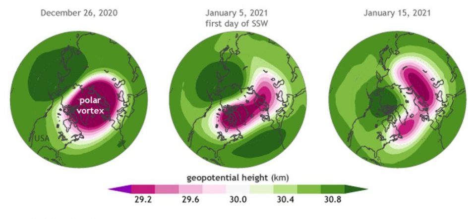
However, the vortex is occasionally ‘knocked off’ when very strong atmospheric waves in the troposphere break into the stratosphere, creating a spike in polar stratospheric temperatures (called Sudden Stratospheric Warmings (SSW)). This could result in the vortex slowing or splitting into several lobes (see diagram below). After a lag of a few weeks, the polar jet stream will start to ‘sense’ these stratospheric changes and become more ‘meandering’, bringing warm air into the Arctic while also spilling (warmed but still very cold in relative terms) Arctic air further south. This phenomenon also coincides with the Arctic Oscillation (which tracks hemisphere scale wind and pressure patterns) entering the negative phase.
The question of whether SSW events are impacted by climate change has not been answered definitively. Although the Earth has warmed about 1 deg C over the past 50 years, the Arctic has warmed at more than double this rate due to ‘positive feedbacks’ caused by increased heat absorption as the reflective surface area of ice and snow shrinks. Physical theory dictates that due to reduced north/south temperature difference, the jet stream ought to weaken – resulting in slower moving, wavy patterns that are more likely to result in mid-latitude winter storm events.
However, an increasing trend in SSW events is not apparent within the relatively short historical record starting in the 1950s, punctuated with significant decadal variability (such as the notable absence of events in the 1990s). Due to the inherent complexity of interactions at the stratosphere/ troposphere boundary, climate models also project differing views with some predicting the strengthening while others, a weakening of the vortex[3].
|
Schematic illustrating disruption of the polar vortex in the lead up to the Texas snowstorm. Note that geopotential height approximates actual height of the same pressure surface. As cold air is more dense than warm air, heights are usually lower at the North Pole. However, this suddenly changed after the SSW warming event shown above. |
Unique characteristics of the Texas snowstorm, and could it happen elsewhere?
The significant losses and widespread disruption from Uri in Texas as well as other winter storm events mean that although the jury is still out regarding the extent of influence from climate change, there is a compelling need to be better prepared in the future. For the northern hemisphere, the geographical extent and timing of the cold air penetration will largely depend on the configuration of each individual polar vortex event. As such, all areas located within the mid latitudes within both hemispheres are potentially exposed – with extent of impact largely determined by the resilience of each region/country.
During Uri, Texas was especially hard hit compared to other states due to a unique and unfortunate confluence of factors, particularly its power grid which is standalone (due to political and cost reasons) and thus lacked the ability to import electricity from neighbouring states which are part of a broader interconnected grid system. Although some were quick to point the blame squarely at renewable energy sources, the prolonged power outage was compounded by several factors.
Firstly, Texas typically experiences peak electricity demand in the hot summer months, thus shifting scheduled maintenance to winter. Next, generating capacity from both traditional and renewable sources were adversely impacted. Unwinterised natural gas (the largest producer of Texas state-wide energy) reduced by 25% in capacity at one point, wind turbines ill-equipped with heating lubricants failed, and coal fired and nuclear power plants suffered from ice build up and frozen pipes. On the demand side, the extreme cold caused a surge from home based electrical heating, and with 71 GWs required and only 51 GW available, millions were left without power.
With an improved appreciation of the loss driving factors above, other nations situated within the mid-latitudes that share similar characteristics to Texas may also be at heightened risk from future events. For example, Taiwan has a standalone grid. Its large population, high economic density, small island land mass and sub-tropical climate appears makes it particularly vulnerable to winter storms, especially given the complex inter- dependencies of microchip supply chains, and as it ramps up on renewable power generation capacity from offshore wind farms.
In fact, the widespread 2008 cold break across large swathes of southern China, and just missing the island serves as a stark warning. Other developing nations associated with a warmer climate, and possess less resilient power infrastructure such as Bangladesh, Mexico, Chile, India and several Middle Eastern states have all suffered from damaging cold outbreaks in the past and need to be better prepared especially if polar vortex impacts are indeed confirmed to be perturbed by climate change.
On a related note, while the polar vortex is largely associated with the outbreak of cold air from the north, in the Southern Hemisphere, and acting in tandem with other climate modes such as the Indian Ocean Dipole and ENSO, it has also been also associated with reduced rainfall that contributed to the record 2019- 2020 Australian bushfire event[4].
Preparation for future events will be critical
Although it is impossible to accurately predict when and where the next damaging winter storm will strike, the severity of the peril alone warrants a more proactive approach towards risk management. To this end, long term investments in grid maintenance, backup plans and cold-proofing critical infrastructure will be key. In particular, efforts to upgrade/ or transition towards renewable energy sources must not neglect the robustness of these assets to a plethora of perils, including winter storm.
The success story of the Texan city of El Paso during winter storm Uri (where there were minimal disruptions while the rest of the state was down) is clear evidence of the benefits of learning from previous disasters and investing for a safer future. After being severely impacted by the 2011 ‘Groundhog Day blizzard’, it adapted of many of its existing facilities for prolonged operation in freezing temperatures – ensuring that valves, transmitters and pipelines were adequately insulated[5].
For the rest of the state, authorities ought to consider moving from an ‘energy on demand’ only model, where producers are not incentivised to carry any spare capacity, towards a capacity-based model. Correspondingly, residents may also need to accept a higher cost of electricity to increase grid resilience to future events, which will also help prevent a repeat of extreme price hikes where unwitting customers were charged exorbitant prices for a few days of power during the height of the storm
Short term near real time event management can also lead to improved outcomes, although these will always be far less effective compared to longer term resilience investments. With respect to Texas, authorities had ample warning from the National Weather Service more than a week in advance (and as early as 5 February, 10 days before the event), which may have been enough time to mitigate against full blown power cuts[6].
Akin to how evacuation or ‘hunker down’ orders are issued as a tropical cyclone is forecast to make landfall in a particular area, more rigorous scenario analyses or simulated ‘grid stress tests’ could have been performed to identify key risk factors and inform appropriate response strategies. These event response measures should then have been summarily communicated and an emergency framework involving active engagement and participation from the broader community clearly set out. For example, this could include pre-emptively advising the public to prepare for blackouts especially those living in poorly insulated homes. In addition, as significant electricity demand in Texas comes from heavy industry, careful scenario planning may encompass planned outages at targeted non-critical industries during the height of the winter-storm, ensuring that residents are protected first.
|
References [1] https://www.cbsnews.com/news/texas-winter-storm-uri-costs/ [2] https://www.climate.gov/news-features/blogs/enso/sudden-stratospheric-warming-and-polar-vortex-early-2021 [3] A tug of war over the mid-latitudes, Nature Communications, 2019 [4] Rare warming over Antarctica reveals power of stratospheric models, Nature, 2019 (https://www.nature.com/articles/d41586-019-02985-8#ref-CR1) [5] https://www.texasmonthly.com/news-politics/el-paso-electric-winter-storm-2021/ [6] https://www.washingtonpost.com/weather/2021/02/19/texas-cold-early-warning/ |
CPD: Actuaries Institute Members can claim two CPD points for every hour of reading articles on Actuaries Digital.